Marathons, Mountains, and Microbrews - New England
The thick, black ooze worked its way rapidly up my leg. "I wonder just how deep this mud is," I thought. I pulled my foot out easily, but I'd wear the mud for the rest of the day.
Thursday, 25 September 2003 4:00 a.m. My alarm clock rings in Martin, Michigan. I'm ready for an intense weekend as I head for the shower.
11:00 a.m. I landed at Logan Airport in Boston, picked up my rental car.
This weekend, I'm not going to be satisfied with one state highpoint. I'm
going for 5.
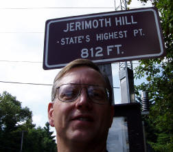
1:00 p.m. Arrived at Jerimoth Hill, elevation 812, the high point in Rhode Island. Actually, the high point is a few yards away across private property, but the Highpointers club officially recognizes the sign at the roadside as meeting the requirement. A couple quick pictures, and I'm headed across Connecticut.
4:36 p.m. I arrived at the trailhead for the hike up Mt. Frissell, elevation 2380. My first climb of the weekend. The sunshine is gone and the sky is growing gray. I parked at the state line and headed up the trail.
 |
 |
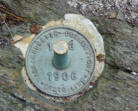
The high point of Connecticut isn't actually the summit of the mountain--the summit is in Massachusetts. I found my way to the summit, signed the log, then went about 5 minutes farther down the trail to the high point, marked by a cairn and a survey spike. Seven minutes further down the trail is the corner where NY, CT, and MA connect. After visiting the stone monument at the corner, I headed back to the car, the wind and rain picking up a bit as I went. The car heater felt great as I got back on the road and headed up US 7 toward Mt. Greylock.
7:35 p.m. Hey, what do you know--the Berkshire Brewery is just north of Great
Barrington, and right on the way to my next summit. I stopped for a Brown Ale
and a sandwich, and at 8:30 was back on the road heading north. It was way
after dark, but around 9:00 I found the right road and at 9:36 arrived at
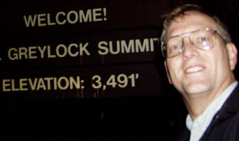
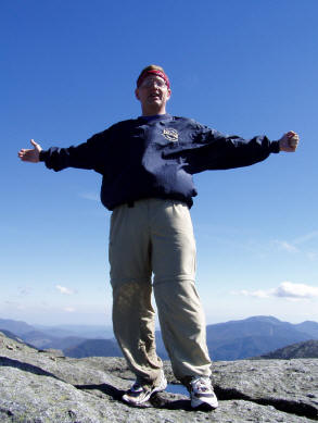
the summit of Mt. Greylock, elevation 3491, the highest point in
Massachusetts. High winds and light rain at the summit made it difficult
to change batteries as I fought with my digital camera to get some good shots.
Now, if I had realized how long the drive to Lake Placid was, I might have come up with a different plan. I pulled off the road for about an hour nap, and finally rolled into Lake Placid at 3:30 a.m. The lady at the motel counter scratched the words "NO SHOW" off my reservation slip and gave me my key. Twenty-four hours after I heard my alarm go off, the my last memory of the day is the beep-beep of my watch signaling 4:00 a.m.
Friday 7:00 a.m. I didn't dare hit a snooze alarm--just got up and showered, grabbed a quick breakfast at a convenience store, and drove the 11 miles out of town to the trailhead for Mt. Marcy (elevation 5344). The trail guidebook I have says 8-12 hours. I really didn't want to spend that long, but, hey, I'm a marathon runner--so who needs to rest going up a mountain.
The climb would be nearly 15 miles up and back. At about 8:55 I started up the
trail. A little while
 later I realized that in 9 hours it would be dark. I
really didn't want that. I hustled along at a reasonable pace, passing
someone every now and then. At one point, I lost track of the trail, but I
was still heading up hill, so I figured the trail I was on would intersect
another one soon, so I gave it a few more minutes. I was walking up what
appeared to be a stream bed, but lots of rocks to step on were letting me keep
my feet dry. Sure enough, I ran back onto the trail system and the familiar
blue markers which indicated the trail to the Marcy summit. After 3 hours and
25 minutes, I arrived at the summit, just before 12:30 p.m.
later I realized that in 9 hours it would be dark. I
really didn't want that. I hustled along at a reasonable pace, passing
someone every now and then. At one point, I lost track of the trail, but I
was still heading up hill, so I figured the trail I was on would intersect
another one soon, so I gave it a few more minutes. I was walking up what
appeared to be a stream bed, but lots of rocks to step on were letting me keep
my feet dry. Sure enough, I ran back onto the trail system and the familiar
blue markers which indicated the trail to the Marcy summit. After 3 hours and
25 minutes, I arrived at the summit, just before 12:30 p.m.
The trip down was uneventful, except for one moment of uncertainty. Most of the muddy spots were no deeper than the bottom of my shoe. That meant I was pretty surprised when I stepped in some mud and was suddenly sucked in halfway to my knee. It's funny how fast my mind was wondering just how far down I would go. Fortunately, my other leg was on solid ground and I extracted myself pretty fast.
After crossing Marcy Dam there were about two miles of trail left, and it actually gets runnable. So, after 6+ hours of hiking, my brain suddenly went into running mode, and with backpack and all I started running the rest of the way back to the trailhead. Total round trip time 6 hours, 34 minutes! I changed into dry clothes, washed the mud off my feet, and headed back to the Lake Placid Brewery. A pint of UBU Ale, a pint of Barkeater Amber, and a steak were just what the doctor ordered (or some other overused cliché, if you prefer).
I got into Vermont just in time to see the sunset. Unfortunately, I was heading east at the time, so I pretty much missed it. In fact, I missed most of Vermont due to darkness. What I didn't miss, however, is lots of two lane roads that have double yellow lines in the middle of them and someone slow right in front of me. Anyway, I finally arrived at about 11:30 in Gorham, New Hampshire. "Hey--I should get a good night's sleep tonight."
Saturday, 6:30 a.m. That's enough sleeping. After breakfast, I decided to do a little laundry. The shoe I had so thoroughly stuck into the mud just happened represent half of the shoes I planned to wear in Sunday's marathon. So, I caught up on some reading and washed my shoes along with my climbing clothes.
 |
 |
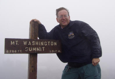
If I weren't running a marathon tomorrow, I'd climb Mt. Washington (elevation 6288). Just as well.
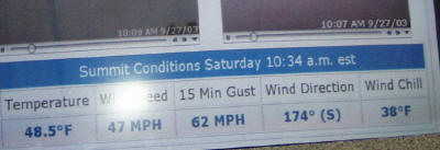
The guy at the toll booth said the weather at the top was 45 degrees, foggy, and 65 mph winds. He wasn't lying. I drove up, enjoying the scenery with no guardrails on the just-wide-enough-for-two-cars road. The CD which was included with the price of admission gives a guided tour on the ascent and the descent making the drive both enjoyable AND educational. I put on my fleece and my windbreaker before getting out of my car at the summit, and with the rain/sleet doing its best to blow me off the rocks at the peak, I bagged my 5th state high point in three days at 10:30 a.m.
Now, on to the marathon. I headed down the mountain and in a generally southerly direction. At 1:05 p.m. as I drove into North Conway, "What's this?" The Moat Mountain Smokehouse and Brewing Company! And to think I hadn't had lunch yet! Bear Peak Brown and Violet B's Blueberry Wheat, a sandwich and a Michigan football game. Did I plan that one right or what!
I finally arrived in Keene, New Hampshire at 5:30. Just in time to check into the hotel, pick up my packet, and have a pasta dinner. A quick trip to the Elm City Brewery and I was ready for a quiet, pre-marathon evening.
The Clarence DeMar Marathon is named after the guy who won the Boston Marathon seven times, and starts in Gilsum, NH. About the time we got off the bus at Gilsum, it started raining. I don't know if it's stopped yet, but it certainly didn't that day. Fortunately, it was around 65 degrees, so the rain had a nice cooling effect.
The course is beautiful, with the first few miles following a small river as we wound our way back toward Keene. For 15 miles, I managed to average about 9 minute miles, but with the extra mileage on my legs for the weekend, I slowed a bit after that. We went into some hills around 17-18, but nothing too serious. I was feeling strong, just not as fast as I wanted to be. Around 24 miles, I got a little burst of energy and finished the last couple miles at a good pace, with an overall time of 4:20:01, about my 5th or 6th best time ever out of 84 marathons.
I showered and headed back to Logan Airport. At 1:00 a.m. I was back in Martin, Michigan in my own bed, and at 8:00 Monday morning was back at work.
Overall stats:
5 State High Points
4 Microbreweries
3 new glasses for my beer glass collection
2 kick-ass mountain climbs
1 marathon.
48 states marathons to date
10 state high points
and the adventure continues....
Don Kern
www.cooladventures.net